Physiographic Provinces & Ecological Communities
Used with permission from Karl Anderson's
"Winter Botany course".
Physiographic Provinces of New Jersey and Major Terrestrial Ecological Communities Associated with Them
Ecological
communities are assemblages of plants and animals that can be found
more or less predictably on all sites in a given region, that have
identical conditions of soil, hydrology, climate, and disturbance
history. They are usually, but not always, named for their dominant
vegitation. They can be very broadly defined or very narrowly defined.
Some ecological communities of New Jersey can be found in only one physiographic region; other communities can occur in all of them(though this depends on how narrowly each community is defined). Likewise, some plants and animals are found in only one community, while others are widespread.
Some ecological communities of New Jersey can be found in only one physiographic region; other communities can occur in all of them(though this depends on how narrowly each community is defined). Likewise, some plants and animals are found in only one community, while others are widespread.
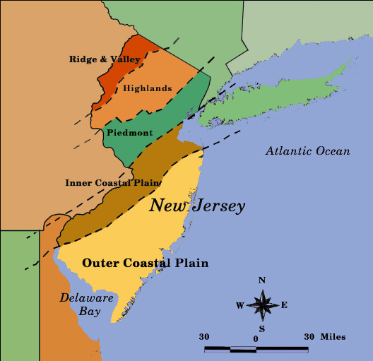
Ridge and Valley
635 square miles; 8.5% of the area of New Jersey, about 5% of the population. Characterized by the Kittatinny Ridge, which is the eastern outlier of the Appalachian Mountaiins, and the valley to the east, which is part of the Great Valley of the eastern United States. Exposed rocks are Silurian and Devonian sandstones, quartzites, and shales ( up to 400, 000, 000 years old); Great Valley is underlain by limestone. Was completely glaciated during last ice age. Relatively high elevation and northern and inland location makes for somewhat "northern" climate and a northern component to the flora and fauna. Includes parts of Sussex and Warren Counties. Major ecological communities include:- Ridgetop pitch pine-scrub oak forest
- Talus slope
- Chestnut oak forest
- Northern mixed oak forest
- Hemlock-mixed hardwood forest
- Sugar maple-mixed hardwood forest
- Hardwood swamp
- Glacial bog
- Inland white cedar swamp
- Black spruce swamp
- Emergent marsh
- Grass-sedge marsh
- Shrub swamp
- Limestone rock outcrop
- Limestone glade
- Limestone fen
- Limestone pond shore
- Pond shore
- Successional communities
New Jersey Highlands
900 square miles; 12% of the area of New Jersey; about 5% of the population. Characterized by old (pre-Cambrian) mountains, with much-eroded rocks up to 1, 000,000,000 years old. An extension of the New England Upland (Taconic Mountains) and Hudson Highland (Ramapo Mountains). Typical rocks are gneiss, marble, and conglomerate. Large deposits of iron, zinc, and other minerals have been extensively worked. Includes parts of Sussex, Warren, Passaic, Morris, Bergen, Hunterdon, and Somerset Counties. Ecological communities are much like those of the Ridge and Valley except for the lack of limestone:- Ridgetop pitch pine-scrub oak forest
- Talus slope
- Chestnut oak forest
- Northern mixed oak forest
- Hemlock-mixed hardwood forest
- Sugar maple-mixed hardwood forest
- Hardwood swamp
- Glacial bog
- Inland white cedar swamp
- Black spruce swamp
- Emergent marsh
- Grass-sedge marsh
- Shrub swamp
- Pond shore
- Successional communities
Piedmont
1500 square miles; 20% of the area of New Jersey; about 60% of the population. Characterized by rolling terrain, underlain by sedimentary rocks (red shales) of relatively recent (Triassic) origin (about 200,000,000 years old); with rocky ridges and outcrops (Watchung Mountains, Sourland Mountain, Snake hill, the Palisades) of igneous origin (basalt and diabase). Very densely populated. Includes part or all of Hudson, Bergen, Passaic, Morris, Essex, Union, Middlesex, Mercer, Hunterdon, and Somerset Counties. Ecological communities are often fragmented and degraded, but include:- Chestnut oak forest
- Northern mixed oak forest
- Hemlock-mixed hardwood forest
- Sugar maple-mixed hardwood forest
- Hardwood swamp
- Emergent marsh
- Grass-sedge marsh
- Shrub swamp
- Pond shore
- Successional communities
Inner Coastal Plain
1075 square miles: 14.3% of the area of New Jersey, 14% of the population. Characterized by relatively flat terrain, underlain by sands and gravels of Creataceous origin (about 100,000,000 years old) with meandering rivers which drain to Raritan or the Delaware River. Includes parts of Middlesex, Mercer, Monmouth, Burlington, Camden, Gloucester, and Salem Counties. Ecologically, has some affinity to the Piedmont, some to the outer coastal plain. Ecological communities include:
- Southern mixed oak forest
- Upland pine forest
- Beech-oak forst
- Red maple-sweet gum forest
- Virginia pine successional forest
- Coastal white cedar swamp
- Hardwood swamp
- Emergent marsh
- Freshwater tidal marsh
- Successional communities
Outer Coastal Plain
3400 square miles; 45.2% of New Jersey, about 16% of the population. Characterized by relativiely flat terrain, underlain by the sands and gravels of relatively recent geologic origin. Separated from the inner coastal plain by a low ridge, marked by hills ("cuestas"), such as Beacon Hill, Arney's Mount, Mount Holly, and Mullica Hill. Stream drainage is generally to the Atlantic. Includes part or all of Monmouth, Ocean, Burlington, Camden, Gloucester, Salem, Cape May, and Atlantic Counties, and includes the Pine Barrens plus salt marshes and barrier islands. Has a fairly strong southern component to the flora and fauna. Ecological communities include:
- Southern mixed oak forest
- Upland pine forest
- Upland oak forest
- Pine plains
- Red maple-sweet gum forest
- Virginia pine successional forest
- Coastal white cedar swamp
- Pitch pine lowland forest
- Hardwood swamp
- Pine barrens shrub swamp
- Emergent marsh
- Freshwater tidal marsh
- Pine barrens savannah
- Salt marsh
- Coastal dune grassland
- Coastal dune shrubland
- Coastal dune forest
- Successional communities