The Maurice River Reaches Project
Basket Flats
Reach #48
Lifetime Port Norris residents Warrington Hollinger and Lou Capaldi have witnessed the way tides and time have tampered with the shorelines of the lower Maurice River. During their lifetime, there have been efforts to harness the tides so that man and nature formed a fertile collaboration.
Family farms were expanded when meadows along the river's shores were banked. Lighthouses brought ships into safe harbor. Catches and hauls of each season sustained the watermen of the Maurice River.
But in the twentieth century, efforts began to wane. Capaldi's family became the last to give in to the tides, finally foregoing the repairs to the banks and shifting their efforts to higher lands. Hollinger pointed out two sunken barges, the General Pershing and the Perseverance, that the state planted in the riverbed to help prevent further land from being swallowed up by the river.
From his Port Norris office, Hollinger looks out over the Maurice River from a building that housed the US Customs Office and Office of the Division of Shellfisheries at the height of the region's oyster industry. In the 1950's, when a natural parasite decimated the oyster beds and the local economy, there weren't many options or incentives to fight the forces of nature.
Both Capaldi and Hollinger named the reach known as Basket Flats as a prime example of the losing battle to maintain the riverbanks that they knew in another era.
Basket Flats was a low-lying stretch of land very close the mouth of the Maurice River. It was firm enough for the crews of oyster boats to cart the load from the oyster boats out to the baskets stacked on the shoreline. From this marsh, the baskets were carted over land to the shucking houses.
Capaldi said that here, at the beginning of this century, Basket Flats was almost a memory. "It's almost all gone, " he said.
"It took from 1950 until now to lose all of this," Hollinger said. "And one of these days, you're going to look out - and you're going to see nothing but the bay." He located the spot that was once Elder Point and pointed out the shrinking shape of Fowler's Island. "At one time this was all joined together," he said." There was just a little spot called Taylor's Gut. It started to break open in 1950.You could jump across it," he said.
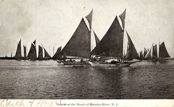
Basket Flats is captured in a turn-of-the-century photo in Donald H. Rolfs' book, Under Sail - The Dredgeboats of the Delaware Bay. A caption with the image reads: "Perhaps this is why Basket Flats received its name. Dregeboats unloading below Bivalve because of the ice up river." Another photo, taken in the winter of 1905, shows the schooner Henry S. Robbins moored at high tide near the mouth of the Maurice River. (Photos credited to G. Hinson)
While the land mass may be disappearing, the name of the reach hasn't washed into the bay. Today the NJ Marine Police use many of the Maurice River reach names on their patrols. Basket Flats is one of their reference points as they navigate the winding waterway.
 click to navigate the map "up".
 click to navigate the map "down".
 click to navigate the map "left".
 click to navigate the map "right".
 click to "zoom in" for a closer look.
 click to "zoom out" to back away from the map.
 click to get back to the "default" map setting.
 click to learn more about that reach.