The Maurice River Reaches Project
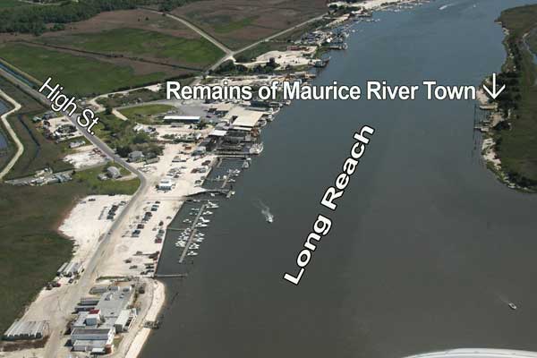
Long Reach
Reach #46

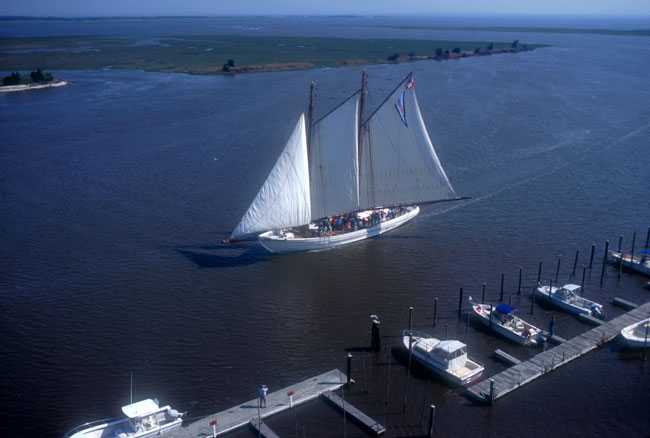
"John is in the yawl boat today and will pull the Rose M. Gaskell out into the river," wrote local resident Joseph Gaskell. Gaskell captured the scene in a book he dedicated to the memory of his father, Captain "Shave" Gaskell.
 The passage describes one of the Maurice River adventures that he shared with his brother John and their father. Gaskell wrote: "…the men on deck start to set the sails on her…the yawl boat is aft now, pushing us from the stern, heading down Long Reach, moving along good now. We're heading for Northwest reach now."
These reach names are as familiar to local boaters and fishermen today as they were two centuries ago. A reference to Long Reach was made in a deed dated 1796. Payday's Ditch, also mentioned in an old deed, is described as a cut leading out of the Maurice River on the eastern side, and near the lower end of Long Reach.
In the booklet, "History of Commercial Township," the authors (Mints, et al.) refer to a map drawn in England in1691. The authors wrote: "Bivalve was then known as Clark's Landing. It later became Long Reach. Most of the land was owned by a family named Robbins in Dallas Ferry. They sold it to the Central Railroad who put up the shipping houses and piers along the river's edge and leased them to businessmen."

The activities of the industries defined life along this southern stretch of the Maurice River. About midway along this lengthy reach is where Commercial Township's oystering community, Bivalve, was situated, On the opposite shore, in Maurice River Township, was the village of Maurice River. The history of the oyster and clam industries has flavored these two locales.
In the History of Commercial Township, the authors reported that there were U.S. Customs Houses at Bridgeton, Mauricetown, Goshen and Bivalve. In 1907, these were consolidated at the Bivalve site, which the authors described as the smallest customs house in the United States. Another government agency, the NJ Oyster Investigation Laboratory, had a station and a wharf at Bivalve for oyster research. (Read more in Reaches # 42 and 45.)
Transportation, via river and rail, was one of the critical factors that fostered economic success along this portion of the Maurice River. The Port Norris Ferry provided service across the Maurice River from Bivalve to the town of Maurice River between 1889 and1932. In an article, "Maurice River Railroad," published in South Jersey Magazine (Summer 1975), writer Don Wentzel noted, "A small station was built on the west bank of the river at Hand's Wharf to accommodate passengers. At Bivalve you could board a trolley or a train on the Jersey Central for Port Norris or Bridgeton."
Transportation over land was important, too, as horses and then automobiles carried passengers and cargo inland. In the booklet "History of Commercial Township," the authors described a corduroy road (a road created by laying logs over a dirt surface) that was built between Long Reach and Port Norris. The logs were cedar, which was plentiful in the early years. In later eras, "shippers carted oyster shells by wheel barrow and made the road." The authors concluded, "Until the present today it is known as the Shell Road."
Both shores of the Maurice River at Long Reach were severely impacted when the oyster industry went into decline in the mid-1900's. Today two marinas, Long Reach Marina and Port Norris Marina are popular with boaters.
One of the most recent references to Long Reach was in an article in the Bridgeton News, dated Monday, April 10, 2006. The article reported that:
" A Coast Guard helicopter rescued three men after their boat capsized while they were fishing in the Delaware Bay Sunday morning.
The men had been anchored off Egg Island Flat when several waves went over the stern of their boat, …
The helicopter from the Coast Guard's Sector Field Office in Atlantic City responded, in addition to two vessels from the Marine Police, a vessel from Port Norris Water Rescue and a vessel from the Cape May Coast Guard station.
The helicopter located the boat at 9:26 a.m. and airlifted the men to Long Reach Marina where medical personnel were standing by.”
 click to navigate the map "up".
 click to navigate the map "down".
 click to navigate the map "left".
 click to navigate the map "right".
 click to "zoom in" for a closer look.
 click to "zoom out" to back away from the map.
 click to get back to the "default" map setting.
 click to learn more about that reach.