The Maurice River Reaches Project
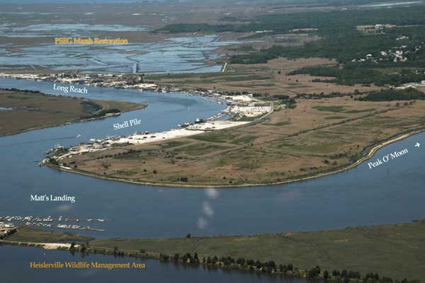
Peak of Moon Dallas Ferry
Reach #43
 Speakeasies and rumrunners. Tories and local militia and a bloody battle. A man named Dallas and a man named Coffee. A rodeo and a racetrack. Salt hay farms and oysters. There's no easy way to encapsulize a place that has all that history. The place is Port Norris. It lies on the western banks of the Maurice River, not very far from the Delaware Bay.
In the beginning, the wide swath of property encompassed 10,000 acres, edging the river and stretching beyond meadow, marsh and uplands all the way over to what is today called Dividing Creek. That tract was surveyed in 1691, by Budd and Worledge for Dr. James Wasse of London. The property was called the Yock Wock tract, for the stream of that name that crossed through it.
In 1728, William Dallas purchased a large parcel of that tract from Dr. Wasse. On the edge of the Maurice, he built a log cabin, established a tavern, and operated a ferry across the Maurice. By 1749, the woodsmen and watermen who came to do business with Mr. Dallas took to calling the settlement Dallas Ferry Landing.
There is one reference that predates the Dallas Landing name. Many decades ago a Port Norris resident, Uriah Lore, related that this point on the Maurice River was once called Yock Wock Landing.
But from the timeframe when William Dallas and then his son Jonathan built up their cordwood business and operated their ferry, this point on the Maurice River was called Dallas Ferry. William Dallas died in 1784. Jonathan continued to operate the ferry until he sold it to a wealthy Philadelphian in 1810. That man was Joseph "Coffee" Jones. (It is surmised that Joseph's nickname was a reference to the wealth he accrued as a result of his father's financial success in the coffee market.) In 1812, Coffee Jones renamed the town in honor of his son Norris and thus it became Port Norris.
With a start like that, it isn't hard to understand why so much legend, lore and hard-to- believe truths are attached to this part of the Maurice River. Looking back to the time of the Revolutionary War, one of those truths is the account of the Battle of Dallas Ferry. It is recorded as the only Revolutionary War battle in Cumberland County where blood was shed. As recorded by local historian Herbert Vanaman, there are two accounts of the battle. One report, printed in the Philadelphia Bulletin on Aug 29, 1781, just days after the incident, called the fighting a "sharp conflict" that ended in the deaths of all 15 Tories, or refugees, as the Tories were sometimes called. The captain of the local militia was Captain James Riggins. Vanaman added that the battle occurred on the Maurice River between Menhaden on the east and the Port Norris meadows on the west.
Lifelong resident Lou Capaldi owns farmland adjacent to the site of this battle. He related that some artifacts were found in the vicinity. He would like to see the state designate a section of the area as an historic site. Capaldi created his own marker to let visitors know about it when they are coming along Route 553 into Port Norris and to the Peak of the Moon.
Peak of the Moon is a name that is subject to conjecture. Local reisdent Everett Turner said that years ago, old-timer Ned Stowman revealed what he knew about the name of this Maurice River reach. Turner related Stowman's version: "It was a good place for rumrunning - during the prohibition days. During the peak of the moon - that was during a full moon - the rumrunners could travel the river at night, with no lights or anything, and make their trades for rum, for alcohol. The Peak of the Moon is where they did their trading."
Turner said that the rum trade could be carried out on both shores of the Maurice River at that point, because there was a road on either side. "You could go to Port Norris and you could into Maurice River Township. It was one of few places that fast land went right down to the river in that area," Turner said, explaining that "fast land" is hard land you can drive or walk on. It's land that connects the meadows to the farmland.
Warrington Hollinger is a long-time resident of Port Norris. His memories span decades. Hollinger related how the town came to have a racetrack - and a rodeo. "Now Peak of the Moon was owned by our family for quite a number of years," Hollinger said. "They had a shucking house, (a building where mollusks are opened and the meat is removed from the shell) and a shell grinding plant. At one time we had 500 Chincoteague ponies down there. We had a half-mile racetrack there. We had, similar to Cowtown, a rodeo. This was before the war, of course. We used to have a big celebration there once a year. They paid everyone off in silver dollars."
Hollinger said that his family was involved with the rodeo. "My uncle went down to Chincoteague and bought 500 ponies," Hollinger said. "And then one year there was some kind of disease in the grass. It wiped practically all of them out." Hollinger's uncle returned to the barrier island for more ponies. "Ponies ran all over that meadow for a number of years," Hollinger recalled, adding that there were several barns, but that most of the ponies roamed freely in the meadows, which belonged to his family. That was in the mid-1930's, Hollinger said. " Our family property right at the end of Main Street.”
The history of the town is tied to the oyster industry and the meadows that were once banked to grow bountiful crops of produce and salt hay. When the dikes failed, when the oysters were plagued by the parasites that destroyed the oyster beds, the residents of Port Norris showed their resilient nature. Through the generations, many of the families remained and continue to make their home here along the Maurice River.
 click to navigate the map "up".
 click to navigate the map "down".
 click to navigate the map "left".
 click to navigate the map "right".
 click to "zoom in" for a closer look.
 click to "zoom out" to back away from the map.
 click to get back to the "default" map setting.
 click to learn more about that reach.