The Maurice River Reaches Project
Leesburg
Reach #39
 In 1936, local historian Philip S. Nutt's presentation "Places not Well Known, Near Home," took the audience on a virtual tour of the shipyards in Leesburg and Dorchester. Nutt set the scene: "You will find (that) the old men working in both these yards are artists. They build by hand and eye. It is a pleasure to watch these men work." Nutt was talking about the craftsmen who came to work at these lower reaches of the Maurice River. He explained that these craftsmen had been honing their skills at the shipyards since they were established in the early 1800's.
In this presentation to the Vineland Historical Society, Nutt gave a tidbit about the more recent past (1936). "A few years back they were making government rum-running boats of great power. These boats used to chase bootleggers at sea," Nutt told his audience.
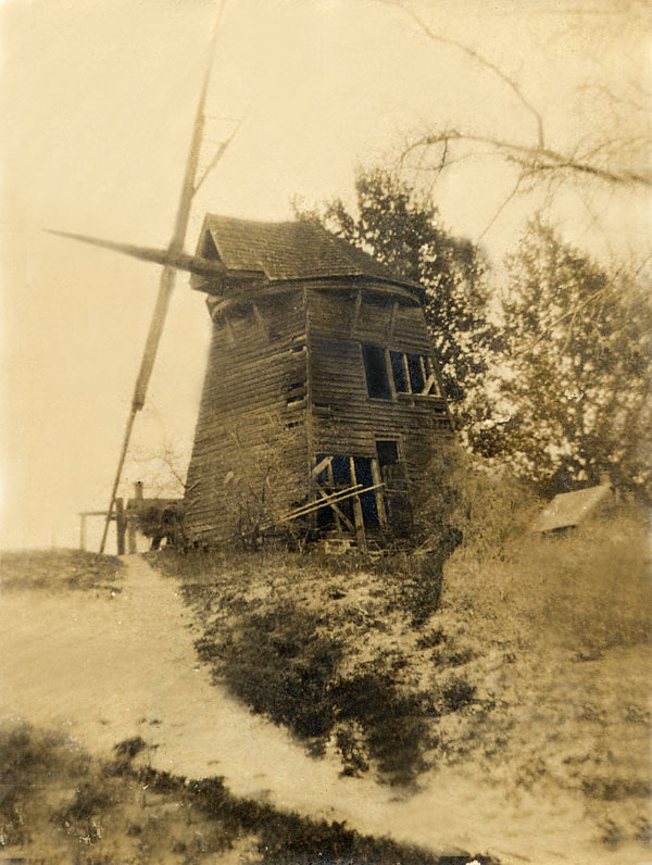
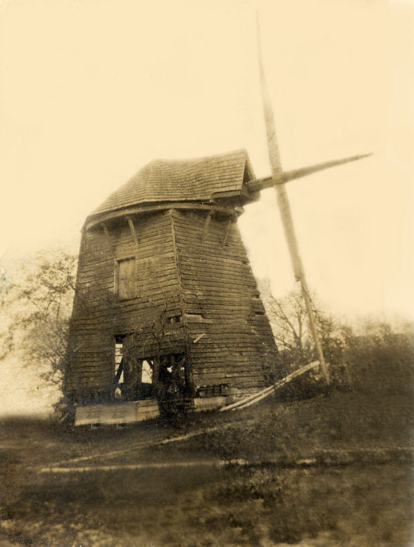
Nutt also mentioned a landmark that once stood on the reach. "If you go down to the river on the one street that leads there, and walk over to the left, in back of the oyster shell building, you can see on a rise of ground four well-built corner-stones where an old Dutch wind mill use to stand. It has all gone now."
Nutt was referring to the windmill that was built by William Carlisle in 1849. In his book, From Whence We've Come, Don Keen published a rare photo of the windmill. Keen noted that "It stood on a small hill on the property of the present Allen Steel Company near the river on High Street in Leesburg. It was used to grind grain." Keen also published a picture of a shed that was made from the wood of this windmill.
 In the Camden Evening Courier dated September 21, 1927, a headline reads, "Famous Old Windmill Now in Ruins." The report proclaimed, "Folks here are mourning the passing of an old windmill, a landmark for years. It was destroyed by a storm last week. The mill was built on the waterfront in 1849 [hard to read; this may not be right year] by William Caryle [Carlisle], one of the first settlers of the town.” The article reported that about 15 years prior to its demise, an unsuccessful attempt was made to raise money for its preservation. The article also gives some background on the man who built the windmill. William Caryle came to Leesburg from Delaware at the age of 19 with only 75 cents in his pocket. He became "the wealthiest man in the region" with 24 farms and 75000 acres of land. The two-story windmill was one of his whims.
 Everett Turner, a long-time resident of the area, recalled seeing photos of the windmill. In fact, he recalled seeing the actual windmill - on the very site where his good friend Jimmy Allen lived and worked. Allen was a craftsman in his own right, Turner said. When the Maurice River Historical Society asked if Allen could help with the cupola for the restoration of the East Point Lighthouse, Allen generously donated his time and created a near-exact replica of the original roof, with all the "little curved pieces and the nitched and notch pieces," Turner said.
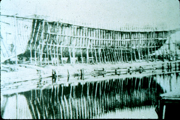
 According to the historian Lucius Elmer, the Lee brothers, who were ship-carpenters from Egg Harbor, established Leesburg around 1800. The 1876 Atlas of Cumberland Countyshows a well-established ship building center there. The map depicts a marine railway with two sets of tracks looping below the Russell Shipyard. An unnamed wharf is also shown. A lime kiln is indicated on the property of Chas. G.Carlisle. The Delaware Bay Shipyard was established in Leesburg in 1928.
At one time, diked farms stretched from just above Leesburg all the way to Millville on the eastern shores of the Maurice River. And across the Maurice River from Leesburg, the meadows of the western shores were banked and farmed as well.
Lou Capaldi, of Port Norris, remembered the farm directly across from the DelBay Shipyard. "That was called the Cook Farm," Capaldi said. "It's all water and mud now." He remembered that, back in the 1940's, the Cook farm had a beautiful house and a barn. Capaldi also recalled the Silverman farm, which was adjacent to the Cook farm.
Charles Hartman created a compilation of maps based on older maps and surveys. One of Hartman's maps shows that, in 1850, Chas. Cook Ferry Road traveled eastward from where present-day route 649 is (north of Port Norris), to the Maurice River, where the Cook Ferry crossed the Maurice River to Leesburg. That Commercial Township road is now called Cook Road.
The acquisition of the Silverman farm added 20 acres to the Capaldi family property. Here they planted lima beans and potatoes. "We had lima beans like you've never seen," Calpaldi said, adding that "there wasn’t a stone in that ground,” making it an excellent place for a potato crop, too. "Potatoes like that, we couldn’t sell them," Capaldi said, indicating the oversized spuds they raised, "so we loaded them on a freight car and they went away to make alcohol." Capaldi said that the land was very rich, "but we were tired of putting up with the dikes. We were about the only ones left. It finally fell in." Capaldi said that his family worked what was probably one of the last diked farms on the southern reaches of the Maurice River.
Based on the Hartman map there was a fish factory, and a factory-centered "village" known as Menhaden. (See Reach #40, Lower Leesburg for more information.)
 click to navigate the map "up".
 click to navigate the map "down".
 click to navigate the map "left".
 click to navigate the map "right".
 click to "zoom in" for a closer look.
 click to "zoom out" to back away from the map.
 click to get back to the "default" map setting.
 click to learn more about that reach.
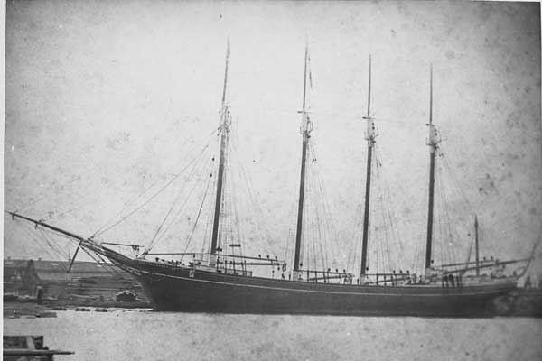